As a native Long Islander, I watched intently as Sandy made landfall. Offshore of NY Harbor, winds gusted up 70 mph and waves swelled to 32 feet in height. A 9ft Storm surge and large spring tides flooded downtown Manhattan. Waves battered the New York and New Jersey coasts. People died and entire communities were lost. Even today, 10 days later, I still have friends that are without power. It was a massive and powerful storm.
Technology allowed the accurate prediction of this storm and enabled officials to make the right calls and evacuate the coasts. And with this technology we can also see how Sandy churned and mixed the ocean.
A recent post by Brian McNoldy explains how hurricanes mix the upper ocean. The upper ocean temporarily become cooler and saltier as warm and fresh water from the surface is mixed with cool and salty water from the deep. Of course I had to see if Sandy did this as well, so I pulled some satellite Sea Surface temperature from NOAA to check it out.

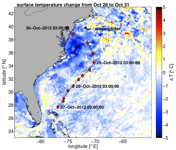
And there is it, the entire Atlantic from about 30-40 N and 65-75 W are noticeably cooler on October 31 after Sandy made landfall. Even big features like the Gulf Stream, which can be seen in the left hand panel of that stream of red water are temporarily cooled. How much did it cool? Let’s check that out too:

Off the Mid-Atlantic bight, cooling up to 5 degrees C can be seen! I can’t really say how this amount of cooling compares to other hurricanes as this is outside of my field of expertise (also hurricane experts can totally bash my analysis if it’s wonky). But if you look at the plot Brian put up of Hurricane Francis, temperatures only drop about 2 degrees, so it seems to me that a 5 degree drop is kinda big news. Of course, the change in surface temperature is not only dependent on how deep the storm mixes the ocean, but also the temperature gradient before the storm hit. I also want to note that there seems to be widespread cooling over the entire Atlantic, but I can’t really answer if this is a real signal or just noise from using daily averaged data.
There is one other piece of information on the plots above, the location of a Liquid Robotics Wave Glider named Mercury that has been in the news recently. Whether driven into the storm intentionally or not, this little robot survived sampling away the entire time (full disclosure: I think these research platforms are really cool, a rep recently came to UAF to give a presentation and I’ve applied for a position with the company). And it got a bunch of data, which again I have pulled using the Marinexplore platform.

You can see sustained wind speeds pick up to almost 90 mph and atmospheric pressure drop as the storm nears the Wave Glider. After the eye of the storm (which didn’t pass directly over the Wave Glider), you can see the winds switch direction and the atmospheric temperatures cool too.
But of course all this data only shows us what is happening at the surface. To look inside the ocean, Rutgers deployed their robot glider into the Hurricane as well. And what they saw on the Jersey continental shelf was mixing. A lot of it.

Above is a plot of turbidity, or how many particles of stuff are in the ocean. The suspended particles can be sediment or biological matter, but this sensor can’t discriminate between the two. When the glider flies beneath the storm on October 29th, turbidity increases. All the gunk in the water indicated that intense turbulence is churning the water, causing sediment at the bottom to be mixed upwards. And in shallow water like this, intense turbulence mixes the entire water column causing sediment to make it all the way to the surface and also cooling the upper ocean.
The awesome power of large storms are clearly evident while on land. And now you know about their huge influence on the ocean too.


Is the pattern of increased variance in wind speed with a sudden drop in barometric pressure (i.e. the arrival of the eye) typical for these events?
Great stuff. With the effect of heat loss from the ocean, makes one wonder how many big storms it would take to start us down the road to another iceage.
Cool article! Could this form of temp reduction be construed as nature’s way of self-regulating ocean temps, a la global warming, or is weather just too chaotic to infer that?
1. Storms at sea are powered by warm water.
2. Heat from the water causes updraft (and thence spinning).
3. The warmed air condenses at altitude, dumping its heat into outer space.
4. Thus the net heat flow is from the sea surface to outer space.
5. Thus every sea storm cools the ocean. And the air. And the planet.
Slight clarification:
3. The moisture in the warmed air condenses at altitude, dumping its heat into outer space.