by Peter Etnoyer
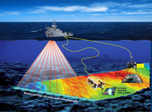
 NOAA’s RV Nancy Foster left port in Gulfport, MS today with a complement of biologists, geologists, remotely operated vehicle (ROV) pilots, and ship’s crew to explore deep hardbottom sites using the SeaEye Falcon ROV. Check out the NOAA OceanExplorer website for the mission plan and cruise track.
Lophelia II 2008 is one in a series of expeditions planning to explore natural and artificial hard bottom communities in the Gulf of Mexico, including deep water oil rigs and shipwrecks, over the course of the next four years. I’ll be on-board to identify gorgonians and to document the expedition in thrilling high-definition
video.
Artificial hard bottom surfaces offer a unique biological perspective because the structures are ‘time-stamped’. We usually know when they were installed or sunk, so we know the maximum age of the fouling community. Sometimes large thickets of the deep-sea coral Lophelia pertusa adorn the hulls of these sunken treasures. See the Past Foundation Website for WWII shipwreck Gulfpenn as one good example.


Such a cool expedition for us landlocked deepsea lovers. Hopefully, we’ll get to see some of your video and comments here soon!
I would hope some of this information ends up in Google Ocean, whenever that finally launches.
Who knows? So far its just a big secret. But I agree it would be nice to georeference some of these images, at the very least.
How close to the edge of the continal shelf are theses sites?
within about 20 km, generally. a map is provided in the Mission Summary section at the NOAA-OE link above.