
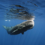
If you’re at all interested in charismatic megafauna (it’s OK, embrace the shame), then you’ve probably heard of satellite tagging before. This is the idea that you can attach a small device to some species of interest and follow its progress and know its location without actually having to be able to see it all the time. These days the devices used for satellite tagging are remarkable bits of technology, akin to a waterproof cell phone or GPS navigator, with all sorts of nifty sensors for depth, temperature, light, even accelerometers (measure motion) and magnetometers (measure magnetic fields). I’ve been using satellite tags for 3 years to track whale shark movements in the Gulf of Mexico and I’m in California this week to work with one company (Desert Star) that makes these tags to learn more about how they work and, especially, how to understand the data that they produce. I thought this was a good time to take a closer look at sat tags and how they work.
On the face of it, the satellite tagging concept is pretty straightforward. Attach tag to animal, animal swims away, tag sends location via satellite, researcher does little joy-joy dance. The truth, as usual, is both much more complex and much more difficult, so perhaps the best way to explore sat tagging is by looking at the challenges that need to be overcome before Al can start jigging around the lab.
Attachment

Challenge 1 really has little to do with satellites and other high tech stuff. It is, quite simply, how do you get the thing to attach to the animal of interest? Water is thick and viscous stuff, relative to air, and applies tremendous drag to any tag you want some animal to carry around for you. Drag means you need some pretty substantial way to affix the device lest it be dislodged, which is unfortunate, because most marine megafauna are not inclined to sit still for you while you attach a cell phone to their back. Further, whatever solution you come up with needs to be minimally invasive and not likely to cause appreciable harm to the wearer, especially for endangered megafaunal species where people’s emotions (for right or wrong) tend to run higher than with, say, little silver fish. Of course, all animals are different too, so there isn’t a single solution that works for all target animals.
With regard to attachment, sea turtles represent the dream animal, because you can catch them up, dry their shell and glue a tag to the highpoint; it doesn’t get much better than that. For whales, on the other hand, you may need to use suckers for short term deployments, surgical solutions for smaller animals that can be handled (this approach is also used in the Shark Men series on Animal Planet CHECK THIS), or tissue anchors that involve a tether in the skin. This last approach is the one used for my research with whale sharks. We use a titanium dart anchor, attached to the tag by a couple of feet of 300lb monofilament, using Nicopress crimp sleeves. The dart is inserted into the skin using a Hawaiian sling hand spear; low tech but pretty effective. Getting the dart in is by no means easy; the skin can be over 3 inches thick and if you don’t have just the right angle and just the right technique, you can end up watching your tag bounce clean off. Whale shark skin is incredible.
Record or report?
The second problem is a function of the watery medium in which the animal swims. Much to the frustration of sub captains and sat taggers alike, water is a terrible medium for transmitting radio waves. In fact, for most intents and purposes you can consider radio transmission for underwater to be a non-starter, especially if you’re talking about a mobile battery-powered device trying to reach an orbiting satellite.

Tag manufacturers get over this problem by making tags of two types: archival and real time. An archival tag is one that records data periodically or continuously when the animal is underwater and then, at some programmed time, it detaches from the animal, floats to the surface and reports all its data via satellite. These tags give you no real-time information such that when you deploy one, you have no idea whether it’s working or not until the programmed detachment date, when you *should* start getting a nice stream of data from the satellite. Archival tags are really the only solution for animals that don’t spend most of their time at the surface, but if your animal tends to break the surface periodically, like marine mammals that must surface to breathe, then real-time tags are a possibility. These tags use the same sorts of geostationary satellites to report locations as the GPS navigator systems like your Garmin, Android or TomTom. Real-time tags are great in that they provide a constant stream of data and you can even respond to the data and go out and find the animal based on most recent location, but they only work in a pretty restricted subset of conditions. Researchers typically have to choose one approach or the other, but recently some tags have been developed that have the ability to archive data when the tag is submerged, and act as a real-time tag when they are at the surface. To do this, the tag uses a stress depth gauge or a wet-dry sensor to tell whether it is at the surface. The model I am using supplements this with an accelerometer reading and will report to the satellite only if the tag is at depth zero and within 20 degrees of vertical (i.e. floating at the surface).
Engine room.
Power is a huge issue for tags. Everything they do, from recording packets of sensor data to sending those data to the satellite, costs stored electrical energy, so the deployment life span of a tag really depends on how much energy they can carry in their batteries. The model I am using overcomes this issue by using a tiny solar panel that gathers energy whenever the animal is near enough to the surface and the sun is shining; for whale sharks, these conditions occur pretty frequently. The tag stores this solar energy in an aerogel capacitor and discharges it as needed, but it also has a battery backup, which provides additional flexibility. Solar would seem to offer a perpetual solution in this respect, but those little photovoltaic cells can and do easily get fouled with marine growth over time, which can really cut their efficiency or even make them non-functional altogether. At the end of the day you’re asking a tiny electrical device immersed in seawater to determine its location and then talk to a satellite tens of miles above the earth’s surface; it’s a wonder they work at all.
For animals that dive, there’s an additional concern about the pressure to which the tag is exposed. It’s not much good recording all those wonderful data if the tag will be crushed to pieces the first time your sperm whale dives in search of Architeuthis. Engineers overcome this by embedding the tags circuity in a block of solid epoxy. This is not your average electronic gadget.
Argos

Nearly all satellite tags use the same satellite network, the CLS-Argos system. These perform beautifully for the most part, but they are neither perfect nor ubiquitous, so tag performance actually is a function of where the tag is, to some degree. The more satellites are overhead when a tag reports, the better is the triangulation of that tag’s location. For example, satellite coverage in the mid-latitudes of the Northern hemisphere (i.e. US and Europe) is great, but coverage in the equatorial zone is not as comprehensive. Sometimes on those rare occasions when a tag surfaces, there is only one or even no satellite overhead, so location recordings can suffer.
Compression.
OK, so a satellite is overhead and the tag is at the surface and it successfully reports to orbit. The next problem is one of bandwidth. The satellites are much in demand and the time, power and bandwidth available very limited, so the sort and amount of data that can be reported are very limited. You can’t for example, get a stream of HD video from a satellite tag (would that you could!). The best you can hope for is a highly compressed packet of data that includes raw info from the sensors in the tag, plus some metadata and diagnostic information that is used to measure the reliability of the other data reported in that packet. Most data require some amount of software processing, and even then, a portion of packets have to be discarded because they are simply not reliable enough.
Interpretation.
In the best case scenario, the tag recorded data and then successfully reported it back via satellite, either while still on the animal or after a programmed detachment. You processed the data and tossed out the bad packets, and all seems well. You’re not home and hosed, not by a long shot. Interpreting those data is a significant challenge especially with regard to location (the reasons for this are long and involved and could be a whole post unto themselves). Briefly, how a tag determines where it is on this globe can happen any of several ways, some easier than others. When a tag is at the surface and reporting via Argos satellite, the GPS location is determined with good accuracy, the same way it is in your car’s nav system. But when the tag is under the surface, determining location is much more challenging. Many tags, like the ones made by Wildlife Computers, determine their location using light levels to determine sunrise and sunset times and then looking for drifts in these times as indicators that the tag has moved either east or west. For example, if sunset is later than expected, it means that the tag moved toward the sunset, or to the west. This approach requires some software processing to calculate locations, and it is very sensitive to species that are not at the surface at dawn and dusk, those critical times needed to calculate location. The tags I’m using use a totally different approach. They have sensors that measure the earth’s magnetic field. Given a known starting point and a limited swimming speed, there is usually only one (or sometimes two) points near enough that can have the observed magnetic field properties. In both cases, the location and time of deployment are really important bits of information and you can’t be futzing around with time zones, so nearly all tags work on Greenwich Mean Time or UTC.
Detachment and recovery.
In a lot of cases, you will never see your tag again: it gets deployed, records data, detaches, reports and then runs out of batteries and that’s that. It’s a $4,000 disposable cellphone. Sometimes, though, you get lucky and get a tag back, and then it’s really time to celebrate. I had one found by a fisherman once, and was able to call my colleague in Mexico and have him go to the guy’s house (I told him the address based on the GPS data!) and recover the tag. Bringing the tag back to the lab and plugging it into the computer allows you access to much better data; instead of getting the occasional packet opportunistically sent by satellite, you get all data from alpha to omega and no bad packets <drool>.
All of this is predicated on correct detachment of the tag as programmed. Detachment, like attachment, is not as easy as it seems. I’ve used two methods, corrosion pin and propellant detachment. In the first, a tiny door in the tag opens at a programmed time to expose a metal pin to the seawater. The pin corrodes and eventually the tag pops off. The propellant approach has a small compartment within the tag that you fill with a little powder charge; on the programmed detachment date, electricity sent to the compartment ignites the propellant and the subsequent expansion of gas shears a plastic pin and releases the tag from the anchor; this should be a more reliable and accurate method. Truth be told, though, more tags come off early as a result of water drag, broken leaders, pulled anchors and even attacks from other animals (towed tags look a lot like fishing lures!), such that the mechanism of detachment is less relevant than overcoming all those other problems of keeping a submarine cellphone connected to an aquatic freight train.
Satellite tags are a phenomenal technological advance. They’ve facilitated tremendous leaps forward in our understanding of what marine animals do after we lose sight of them from the boat. For example, with whale sharks, it was a tag device that solved the mystery of why they dive so deep, and in my own research, satellite tag data showed me what the sharks were doing at night time in Mexico (travelling on the bottom). Bigger programs like Seaturtle.org and the G-TOPP program have really helped organize migration research using satellite tags. As miniaturization continues, I look forward to deployment on ever smaller animals, so that it’s not only the charismatic megafauna that will benefit from these remarkable little devices.


Nice article, Al! Helping a friend who works with turtles, I learned that the Chobani yogurt plastic tub is exactly the right size for mixing up the amount of epoxy necessary to attach a satellite tag to a turtle. For science, I now eat this brand and save all the tubs for her. Sorry I can’t do you a similar favor vis-a-vis whales. :)
A current example tracking a Green Turtle
Tracking Gilbert
http://www.mcsuk.org/conservation_in_action/Marine%20turtles/Tracking%20turtles/Gilbert
Gilbert
Gilbert is a sub-adult green turtle captured at Southern Bush, just south of the Windward Going Through passage between Middle and East Caicos. [Turks and.Caicos Islands] The turtle was too young to accurately tell whether it was a male or female – but we are guessing he is male. Gilbert was captured by TCI Turtle Project Officer Amdeep Sanghera on a sampling trip with legendary TCI turtle fishers Gilbert Jennings and Dave Clare.
The turtle is fitted with a Sirtrack Fastloc tag to determine its fine scale movements in its tidal foraging habitat. The purchase and deployment of this tag is supported by the National Marine Aquarium, Plymouth, with additional project support from the People’s Trust for Endangered Species.
…..
UPDATE 01.06.12: Well this is exciting! Gilbert’s odd behaviour earlier this week seems to have been preparation for a migration! This may be one of the first sub-adult green turtle developmental migration ever tracked (possibly a migration from his sub-adult foraging grounds where he was tagged, to an adult foraging ground elsewhere) – where is he going?!