
From NOAA Visualizations on YouTube:
The 2011 Atlantic hurricane season officially ends on Nov. 30 and produced a total of 19 tropical storms of which seven became hurricanes, including three major hurricanes. This level of activity matched NOAA’s predictions and continues the trend of active hurricane seasons that began in 1995.
From Arlene to Sean, Hurricane Season 2011 has been very active, leading to 120 fatalities and causing more than $11 billion in property and infrastructure damage. Surprisingly, none of the first eight tropical storms reached hurricane status, a record since reliable reports started in 1851. Hurricane Irene’s effects in the Caribbean and the United States lead to 55 deaths and accounted for the bulk of this season’s damage, more than $10 billion. Irene was the first landfalling hurricane in New Jersey in 108 years. Hurricane Katia had far-reaching effects causing severe weather in Northern Ireland and Scotland and power blackouts as far east as Saint Petersburg in Russia. Tropical Storm Lee caused major flooding in Pennsylvania, New York and into the Canadian provinces of Quebec and Ontario. The strongest storm of the season was Ophelia, which reached category four strength in the Atlantic Ocean east of Bermuda.
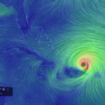
An integral part of NOAA’s ability to monitor and predict hurricane formation and movement is the data that is provided by the GOES satellite, with its visible imagery, infrared sensors, and sounding capabilities. This animations merges both the visible and infrared imagery taken by the GOES East (GOES-13) satellite every 30 minutes over the Northern Hemisphere from June 1 — November 28, 2011. (An update will be provided on December 1, 2011 after the Atlantic hurricane season officially ends).


I SO love stuff like this. Unimaginable just a few years ago