

The view from my desk in the kitchen is a sunny garden near the bay, but Tropical Storm Dolly is moving slowly west from 200 km off the coast here in the Gulf of Mexico. I am “in the Cone“, but seem to be sidestepping the projected landfall as Dolly veers slightly southwest. The one question on my mind, though, is how and will this tropical storm intensify?
I know about Jack Diddly to tell you much about hurricanes, but my oceanography professors at HRI/TAMU-CC are seasoned professionals, so I can share a few things. Yes, that’s “oceanographers” plural. Last year we had a reading class with three professors from different subdisciplines. It was like Star Chamber. They corrected each other and joked about different datasets, models, and authors. I loved it, and learned alot, especially about professors.
The meterological oceanographer told us the development of a tropical storm is an air-sea interaction of the first order. The primary ingredients for a strengthening tropical storm are low wind shear over warm water.
Uh-oh. It was remarkably glassy out on the bay yesterday, and I hear it’s 83 degrees out in the Gulf right now. I look at the cloud map and the storm seems as large as the Coastal Bend region itself, from here down to Brownsville. Should I panic? “Not yet”, I tell myself, “Relax and remember your oceanography”.
The most important thing about a strengthening storm is the cyclone’s primary energy source – the release of heat energy from rising water vapor. The other most important thing is that the ocean is neither homogenous nor static.
From Wikipedia…
Tropical cyclones could be viewed as a special type of mesoscale convective complex, which continues to develop over a vast source of relative warmth and moisture. Condensation leads to higher wind speeds, as a tiny fraction of the released energy is converted into mechanical energy;the faster winds and lower pressure associated with them in turn cause increased surface evaporation and thus even more condensation. Much of the released energy drives updrafts that increase the height of the storm clouds, speeding up condensation. This positive feedback loop continues for as long as conditions are favorable…
The passage from Wikipedia explains why the scale of the cloud map above is “cloud top height”. The map is showing vertical advection of water vapor from the ocean to the atmosphere. But there’s something missing from the map, the ocean topography.
Contrary to popular opinion, the ocean is not flat. Warm water expands and cool water contracts, so there are hills and valleys in the ocean, with very low amplitude, on the scale of centimeters to meters. But these variations can be important to the development of a passing storm. There has been some speculation that one reason Hurricane Katrina developed into such a large, disastrous storm is that the storm crossed over two warm-core eddies that helped to fuel growth along the storm’s trajectory.
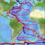
 An image from the DieCAST circulation model show how some eddies are formed in the Gulf of Mexico by pinching off the Loop Current. Cyclonic (cold core, upwelling) and anti-cyclonic (warm core, down welling) eddies sometimes travel in pairs called “modons”. The fronts between these upwelling and downwelling systems are thought to be spawning habitat for billfish and marlin, because high densities of fish larvae are found there.
So, why can’t I see ocean weather maps at Weather Channel? It should be possible, because they both use essentially the same technology. For one, the new channels would probably need to hire an oceanographer to explain them, because the terminology is too backwards and upside-down for meteorologists to adopt easily.
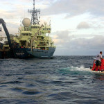
Maybe they could find an ocean weatherman from the offshore oil industry. People don’t think about it much, but the swirling saltwater tornadoes we call “eddies” pose a threat to oil rig operations, because strong currents are associated with their passing. Offshore oil monitors eddy passage regularly. Horizon Marine has a unique program called EddyWatch.
Someday I’ll find a way to pull both these “air weather” and “ocean weather” maps into Google Earth, so I could have my very own weather station, right here in my kitchen, overlooking the sunny garden.


Coral Reef Watch at NOAA comes tantalizingly close with it’s “live” Google Earth feed…but no cigar.